Sea of Japan
| Sea of Japan (East Sea) | ||||||||
|---|---|---|---|---|---|---|---|---|
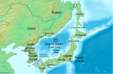
 Map showing the location of the Sea of Japan (East Sea). |
||||||||
| Japanese name | ||||||||
|
||||||||
| English: Japan Sea | ||||||||
| North Korean name | ||||||||
|
||||||||
| English: Korea East Sea | ||||||||
| South Korean name | ||||||||
|
||||||||
| English: East Sea | ||||||||
| Russian name | ||||||||
|
||||||||
| English: Japanese Sea |
The Sea of Japan is a marginal sea of the western Pacific Ocean, bordered by Japan, South Korea, North Korea and Russia. Like the Mediterranean Sea, it has almost no tides due to its nearly complete enclosure.[1] There was a dispute at the United Nations over its official name. Although the issue is still open to discussion, the United Nations confirmed its adoption of "Sea of Japan" in its official documents in March 2004.[2]
Contents |
Geography
The Sea of Japan is bound by the Russian mainland and Sakhalin island to the north, the Korean Peninsula to the west, and the Japanese islands of Hokkaidō, Honshū, and Kyūshū to the east and south.
It is connected to other seas by five shallow straits: the Strait of Tartary between the Asian mainland and Sakhalin; La Pérouse Strait between the islands of Sakhalin and Hokkaidō; the Tsugaru Strait between the islands of Hokkaidō and Honshū; the Kanmon Straits between the islands of Honshū and Kyūshū; and the Korea Strait (genkainada) between the Korean Peninsula and the island of Kyūshū. The Korea Strait is composed of the Western Channel and the Tsushima Strait, on either side of Tsushima Island.
- Greatest depth: 3,742 meters
- Mean depth: 1,753 meters
- Surface area: about 978,000 km²
The sea has three major basins: the Yamato Basin in the southeast; the Japan Basin in the north; and the Tsushima Basin (Ulleung Basin) in the southwest. The Japan Basin has the deepest areas of the sea, while the Tsushima Basin has the shallowest.
On the eastern shores, the continental shelves of the sea are wide, but on the western shores, particularly along the Korean coast, they are narrow, averaging about 30 kilometres wide.
The Tsushima Warm Current, a branch of Kuroshio Current, flows northward through the Korea Strait along the Japanese shore, and the Liman Cold Current flows southward through the Strait of Tartary along the Russian shore.
The Sea of Japan was once a landlocked sea when the land bridge of East Asia existed.[3]
Extent
The International Hydrographic Organization defines the limits of the "Japan Sea" as follows:[4]
On the Southwest. The Northeastern limit of the Eastern China Sea [From Nomo Saki (32°35'N) in Kyusyu to the South point of Hukae Sima (Goto Retto) and on through this island to Ose Saki (Cape Goto) and to Hunan Kan, the South point of Saisyu To (Quelpart), through this island to its Western extreme and thence along the parallel of 33°17' North to the mainland] and the Western limit of the Inland Sea [defined circuitously as "The Southeastern limit of the Japan Sea"].
On the Southeast. In Simonoseki Kaikyo. A line running from Nagoya Saki (130°49'E) in Kyûsû through the islands of Uma Sima and Muture Simia (33°58',5N) to Murasaki Hana (34°01'N) in Honsyû.
On the East. In the Tsugaru Kaikô. From the extremity of Siriya Saki (141°28'E) to the extremity of Esan Saki (41°48'N).
On the Northeast. In La Perouse Strait (Sôya Kaikyô). A line joining Sôni Misaki and Nishi Notoro Misaki (45°55'N).
On the North. From Cape Tuik (51°45'N) to Cape Sushcheva.
Economy
The areas in the north and the southeast are rich fishing grounds. The importance of the fishery in the sea is well illustrated by the dispute between South Korea and Japan over Liancourt Rocks. The sea is also important for its mineral deposits, particularly magnetite sands. There are also believed to be natural gas and petroleum fields. With the growth of East Asian economies, the Sea of Japan has become an increasingly important commercial waterway.
Naming dispute

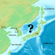
The use of the term "Sea of Japan" as the dominant appellation is a point of contention.
- the Japanese claim that it was commonly adopted during the early 19th century
- the Koreans claim that the change was imposed during the Japanese Occupation (early 20th century - with an official validation in 1929[5]), and that unlike most other names changes forced during that period, it was never reverted afterward.
Both South Korea and North Korea have advocated for the end of what they consider a colonial heritage:
- South Korea wants the "East Sea" name to be restored,[6] and claims that the "Sea of Japan" appellation is not anterior to the "Sea of Korea / Korean Sea" appellation.[5][7]
- North Korea wants the "East Sea of Korea" name to be restored.[8][9]
As a result of Korean objections to the name "Sea of Japan," some English-language publications refer to it as "Sea of Japan (East Sea)," incorporating a version of the Korean name.[10][11]
On August 27, 2007, both Korean states made separate proposals to the Ninth Conference on the Standardization of Geographical Names instituted by the United Nations. The conference made no decision on the issue but called on all parties to find a commonly accepted solution. The chairman of the session stated that "individual countries could not impose specific names on the international community and standardization could only be promoted when a consensus existed."[12][13]
See also
- Geography of Japan
- Geography of North Korea
- Geography of Russia
- Geography of South Korea
References
- ↑ "Tides in Marginal, Semi-Enclosed and Coastal Seas - Part I: Sea Surface Height". ERC-Stennis at Mississippi State University. http://www.ssc.erc.msstate.edu/Tides2D/sea_of_japan.html. Retrieved 2007-02-02.
- ↑ "The Policy of the United Nations Concerning the Naming of Sea of Japan". Ministry of Foreign Affairs of Japan. http://www.mofa.go.jp/policy/maritime/japan/un0406.html. Retrieved 2010-04-10.
- ↑ Totman, Conrad D. (2004). "Pre-Industrial Korea and Japan in Environmental Perspective". http://books.google.com/books?vid=ISBN9004136266&id=W_Hdu9QrD9YC&pg=PA16&lpg=PA16&dq=sea+of+japan+landlocked&sig=ZgHV6lie171qNe01EjwpTeeNfOk. Retrieved 2007-02-02.
- ↑ "Limits of Oceans and Seas, 3rd edition". International Hydrographic Organization. 1953. http://www.iho-ohi.net/iho_pubs/standard/S-23/S23_1953.pdf. Retrieved 7 February 2010.
- ↑ 5.0 5.1 East Sea or "Sea of Japan"
- ↑ Ministry of Foreign Affairs and Trade. East Sea.
- ↑ Ministry of Maritime Affairs and Fisheries 2005. The Name East Sea Used for Two Millennia.
- ↑ On Correcting the Inscription of "Sea of Japan" (8th and 9th UNCSGN)
- ↑ Efforts of the Government of Japan in Response to the Issue of the Name of the Sea of Japan (1) The 8th UNCSGN, The Ministry of Foreign Affairs of Japan
- ↑ Sea of Japan and East Sea map information page
- ↑ Sea of Japan vs. East Sea
- ↑ Report of the 9th UNCSGN, 2007
- ↑ Kyodo News, "Despite Korean efforts, geographic conference backs Sea of Japan name," The Japan Times, 29 Aug 07, [1]
External links
 Media related to Sea of Japan at Wikimedia Commons
 The Wiktionary definition of Sea of Japan
|
||||||||||||||||||||